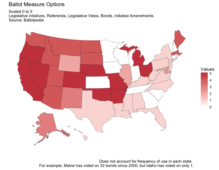
I’ve been working on some map-making skills in R, using the usmap package and ggplot. This coincides with an interest of mine in variation across the states in the prevalence of ballot measures (i.e., direct democracy opportunities). My attempt at mapping this is below, and relies on Ballotpedia classifications here and here.
Getting a good handle on the many ways a question can appear on state ballots is not easy. I counted 5 total options for each state: citizen-initiated legislation, legislatively-referred referenda, citizen-initiatied vetoes of legislation, bond measures, and citizen-initiated constitutional amendments. I did not count whether a state allows for a recall election of an elected official (which is distinct from the policy focus of the above options) or whether voters have to approve constitutional amendments referred to them by their state legislatures (which exists in 49 states).
Moreover, thresholds for getting questions on the ballot vary considerably across the states, which affects how often ballot questions appear.
But, still, the map is insightful, showing the tendency west of the Mississippi vs the South and Northeast. My home state of Maine stands out in the region, along with its older cousin Massachusetts. In Maine, we have 4 of the 5 on the scale, missing only the opportunity for citizens to directly petition for a vote on a constitutional amendment. This hardly holds Mainers back from amending the constitution, however; we’ve voted on over 200 such amendments since 1835 (as referred to us from the state legislature). The median vote on those exceeds 60 percent “yes.”

Pingback: (More) Ballot Questions and Making Maps | Michael Franz